CHCNAV i93
 CHC Navigation / Huace Daohang
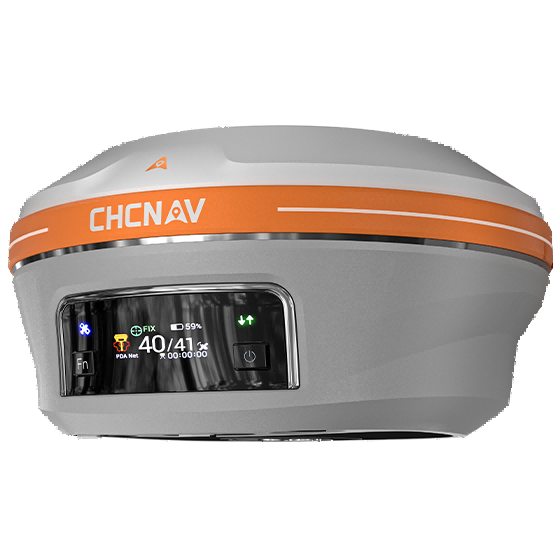
The i93 is CHC Navigation's flagship IMU-RTK GNSS smart antenna, combining a 1892-channel multi-constellation receiver with an auto-tilt IMU and dual cameras for visual surveying and stakeout in centimeter-level precision.
Typed specifications12 values
Discloses 2 of 12 fields engineers filter by in this category (category median 5).
- Mass
- 1 150 g product page
- Position accuracy
- 0.008 m product page 0.015 m
- Tracking channels
- 1 892 product page
- Constellations
- GPS product page GLONASS | Galileo | BeiDou | NavIC +2
- Operating temperature
- -40 °C product page
Each value is typed with its unit and measurement condition and cites the datasheet page it was taken from. Nothing is guessed: a field that is absent here has not been published by the manufacturer. machine-extracted ✓ checked by NewSpace Market ✓ manufacturer confirmed by the manufacturer.
As published by the supplier12 lines, in the manufacturer's own wording
- GNSS constellations
- GPS, GLONASS, Galileo, BeiDou, QZSS, SBAS, NavIC/IRNSS
- Receiver channels
- 1892-channel
- Rtk accuracy (horizontal)
- 0.8 cm
- Rtk accuracy (vertical)
- 1.5 cm
- Pointsky ppp accuracy
- 2.5 cm horizontal / 5 cm vertical
- IMU update rate
- 200 Hz, auto-tilt compensation
- Cameras
- Dual camera system for visual/AR stakeout
- Connectivity
- Bluetooth, Wi-Fi, NFC, 4G LTE, UHF radio modem (410-470 MHz)
- Battery life (RTK rover)
- Up to 34 hours
- Operating temperature
- -40°C to +65°C
- IP rating
- IP68
- Mass
- 1.15 kg
About
The CHCNAV i93 is an advanced IMU-RTK GNSS smart antenna designed for professional surveyors, construction, and mapping teams who need reliable centimeter-level positioning in demanding field conditions. It tracks all major satellite constellations (GPS, GLONASS, Galileo, BeiDou, QZSS, SBAS, and NavIC/IRNSS) via a 1892-channel receiver and uses CHC’s iStar positioning algorithm to maintain a reliable fix even during periods of high solar/ionospheric activity. The unit integrates a 200 Hz auto-tilt IMU that removes the need for bubble-leveling, and pairs this with a dual-camera visual positioning system that enables augmented-reality stakeout and photo-based 3D modeling directly in the field. Built-in 4G LTE and a UHF radio modem, along with Wi-Fi, Bluetooth, and NFC, give it flexible connectivity to CORS networks or CHCNAV’s PointSky PPP correction service. In RTK mode the i93 achieves 0.8 cm horizontal / 1.5 cm vertical accuracy. Housed in a rugged, IP68-rated, magnesium-alloy body rated for 2-meter drops, the receiver runs up to 34 hours as a rover on its 9900 mAh battery, and is marketed for topographic, boundary, and as-built surveys, construction stakeout, and 3D city/infrastructure modeling.
Documentation
No public datasheet yet — request the datasheet / ICD from the supplier.