PAZ X-Band SAR Earth Observation Satellite
 Hisdesat
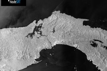
Spain's national X-band SAR satellite — >100 images/day, up to 25 cm resolution, >300,000 km²/day coverage, all-weather day/night imaging with integrated AIS maritime surveillance. Sun-synchronous orbit since February 2018.
Key figurescomparable across the catalogue
- Mass
- 1,342 kg
- Design life
- 7 years
Normalised to common units so this product can be compared with others in its category. The supplier's own wording is below.
As published by the supplier
- Orbit
- Sun-synchronous (SSO), ~514 km altitude
- Launch date
- 22 February 2018
- Launch vehicle
- SpaceX Falcon 9, Vandenberg AFB
- SAR frequency
- X-band (9.65 GHz)
- Best resolution
- 25 cm (Staring Spotlight mode)
- Spotlight resolution
- 1 m × 1.5 m GSD, 4 km × 4 km scene
- Stripmap resolution
- 3 m × 3 m, 30 km swath
- Wide scansar resolution
- 40 m × 40 m, 200 km swath
- Daily images
- >100 images/day
- Daily coverage
- >300,000 km²
- Ais receiver
- Yes — first EO satellite with onboard AIS
- Satellite bus
- Airbus AstroBus-XL
- Launch mass
- ~1,342 kg
- Design life
- 7 years
- Data partnership
- Airbus DS (TerraSAR-X alliance), exactEarth (AIS)
- Operator
- Hisdesat for Spanish Ministry of Defense
About
PAZ is Spain’s first national military Earth observation satellite, launched 22 February 2018 into sun-synchronous orbit at approximately 514 km altitude aboard a SpaceX Falcon 9 rocket from Vandenberg Air Force Base. The satellite carries an X-band Synthetic Aperture Radar (SAR) payload developed by Airbus Defence and Space, providing all-weather, day-and-night imagery with resolutions ranging from 25 cm (Staring Spotlight mode) to 40 m (Wide Swath mode) across multiple imaging modes.
PAZ can capture more than 100 images per day covering over 300,000 km² of Earth’s surface daily. SAR imaging enables surface monitoring through cloud cover regardless of solar illumination — critical for time-sensitive intelligence, border control, and disaster response missions where optical systems are impractical. The satellite is operated by Hisdesat on behalf of the Spanish Ministry of Defense, with civilian data products distributed through Airbus Defence and Space as part of the TerraSAR-X / PAZ data alliance.
PAZ is notable as the first Earth observation satellite fitted with an on-board Automatic Identification System (AIS) receiver, enabling simultaneous real-time maritime traffic monitoring alongside SAR imaging. This capability allows correlation of SAR-detected vessels with their AIS transponder signals, identifying ‘dark ships’ that disable AIS to evade detection. Hisdesat distributes satellite-based AIS data in partnership with exactEarth for commercial maritime domain awareness applications.
Imaging modes include Staring Spotlight (25 cm GSD), Spotlight (1 m × 1.5 m GSD, 4 km × 4 km scene), StripMap (3 m × 3 m, 30 km swath), ScanSAR (18 m × 18 m, 100 km swath), and Wide ScanSAR (40 m × 40 m, 200 km swath). The satellite was built on the Airbus AstroBus-XL bus with a design life of 7 years and total launch mass of approximately 1,342 kg.
Documentation
No public datasheet yet — request the datasheet / ICD from the supplier.