Geoscan 3U
 Geoscan
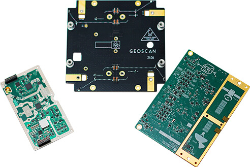
Geoscan 3U is a 3U CubeSat small spacecraft platform developed by Geoscan for educational and technology-demonstration missions, carrying up to four payloads for Earth remote sensing or scientific instruments.
Typed specifications37 values
Discloses 5 of 7 fields engineers filter by in this category (category median 3).
- Mass
- 1.8 kg Modification 1 (truncated configuration), assembled, without … · datasheet p.3 2.3 kg Modification 2 (full set), assembled, without a payload
- Envelope (L×W×H)
- 100 x 100 x 340.5 folded, with separation system locked · datasheet p.3 100 x 100 x 376.5 folded, with Tuna Can
- Power consumption
- 2 W product page
- Data interface
- CAN payload interface (also on-board interface); others on request · datasheet p.3 UART payload interface; others on request | SPI payload interface; others on request
- Form factor
- 3U CubeSat standard · datasheet p.2
- Orbit
- LEO payload average power specified at LEO · datasheet p.3
- Max payload mass
- 4.2 kg max · Modification 1 (truncated configuration) · datasheet p.3 3.7 kg max · Modification 2 (full set)
- Payload volume, U
- 2 U ~2U (95 x 95 x 180 mm) · datasheet p.3
- Payload envelope (L × W × H)
- 95 x 95 x 180 available volume for a payload (~2U) · datasheet p.3
- Power available to payload
- 2 W payload average power at LEO (specified for a specific orbit) · datasheet p.3 15 W max · peak (available maximum output of a payload, specified for a …
- Regulated voltages for the payload
- 3.3–12 V stabilized 3.3...12 V / 2 A (range as printed) · datasheet p.3
- Unregulated bus for the payload
- 7–8.4 V unstabilized 7...8.4 V / 2 A · datasheet p.3
- Attitude control
- other Modification 1: magnetic coils, B-Dot stabilization only · datasheet p.4 3-axis stabilised Modification 2: triaxial orientation (in the sun, at nadir, t…
- Pointing accuracy
- 1 ° max · product page
- Payload data downlink rate
- 57.6 kbps max · UHF low-speed radio channel 435-438 MHz (2400, 9600, 57600 bi… · datasheet p.3 250 000 kbps max · X-band high-speed radio channel 10.45-10.5 GHz, up to; Modifi…
- Radio band
- X high-speed transmitter 10.45-10.5 GHz, Modification 2 only · datasheet p.4 UHF low-speed radio channel 435-438 MHz, turnstile antenna
- Subsystems included
- other 2 MP technology camera; software update via low-speed radio c… · datasheet p.4 X-band downlink high-speed radio channel with antenna array, Modification 2 only | battery Li-ion 2S 7200 mAh, 50 W*h | UHF or VHF radio low-speed radio channel 435-438 MHz, turnstile antenna | GNSS receiver Modification 2 only +3
- Max satellite wet mass
- 6 kg max · maximum weight including a payload, both modifications · datasheet p.3
- Satellite class
- nanosat 1-10 kg educational nanosatellite · datasheet p.2 CubeSat nanosatellite of the CubeSat standard
- Form factor, U (number)
- 3 U datasheet p.2
Each value is typed with its unit and measurement condition and cites the datasheet page it was taken from. Nothing is guessed: a field that is absent here has not been published by the manufacturer. machine-extracted ✓ checked by NewSpace Market ✓ manufacturer confirmed by the manufacturer.
As published by the supplier31 lines, in the manufacturer's own wording
- Assembled weight (without a payload)
- Modification 1 (truncated configuration): 1,8; Modification 2 (full set): 2,3
- Maximum weight of a payload
- Modification 1: 4.2 kg; Modification 2: 3.7 kg
- Maximum weight including a payload
- 6 kg
- Dimensions folded (with separation system locked)
- 100 × 100 × 340,5 (100x100x376,5 with Tuna Can)
- Available volume for a payload
- 95 × 95 × 180 (~2U) mm
- Radiation protection
- aluminum sheet 1.2 mm
- Available supply for a payload
- stabilized 3,3…12 V / 2 A, unstabilized 7…8,4 V / 2 A
- Payload average power at LEO (specified for a specific orbit)
- 2 W
- Available maximum output of a payload (specified for a specific orbit)
- 15 W
- Storage battery capacity, w*h
- 50
- Battery type
- Li-ion 2S 7200 mAh
- Number of solar panels, pcs.
- up to 12 (silicon)
- Peak output produced on 1 solar panel in LEO
- at least 1 W
- Onboard interface
- CAN
- Payload interface
- CAN / UART / SPI, others on request
- Low-speed radio channel frequency
- 435-438 MHz
- Data transmission speed through low-speed radio channel, bit/s
- 2400, 9600, 57600
- High-speed transmitter frequency
- Modification 1: -; Modification 2: 10,45-10,5
- High-speed radio channel data rate, mbit/s
- Modification 1: -; Modification 2: up to 250
- Radio command channel signal modulation type
- frequency
- Type of modulation of a high-speed radio channel signal
- Modification 1: -; Modification 2: phase
- Antenna type of low-speed radio channel
- turnstile
- Antenna type of high-speed radio channel
- Modification 1: -; Modification 2: antenna array
- Maximum transmitter power
- 30…32 dBm
- Orientation system
- Modification 1: magnetometers, solar sensors, horizon sensor, inertial module; Modification 2: magnetometers, solar sensors, horizon sensor, inertial module, GNSS receiver
- Attitude support system
- Modification 1: magnetic coils; Modification 2: magnetic coils, flywheels
- Stabilization modes
- Modification 1: B-Dot; Modification 2: B-Dot, triaxial orientation (in the sun, at nadir, to a point on Earth)
- Orientation accuracy
- up to 1˚
- Attitude system accuracy
- Modification 1: -; Modification 2: up to 1˚
- Additionally
- 2 MP technology camera, Software update via low-speed radio channel, Management of small spacecraft for 1 year after launch
- Documentation
- Passport, Manual
About
The Geoscan 3U is a standardized 3U CubeSat platform developed by Geoscan starting in 2021 as part of the Russian Space-π educational satellite programme run under the Foundation for Assistance to Innovations. It is used to teach satellite design, programming and assembly, to conduct amateur radio communication sessions, to flight-test onboard systems and instruments in low Earth orbit, and to run school, student and scientific space experiments. The platform can carry up to four payloads of up to 2U in volume, such as Earth remote sensing (ERS) cameras and small scientific instruments. Payload connection is via a CAN bus, plus a separate high-speed configurable four-wire LVDS bus for transferring large volumes of data; a dedicated interface board is developed for each satellite, allowing additional connection interfaces to be implemented in agreement with the platform developers. Each unit carries a 2 MP overview/technology camera. Attitude control uses magnetic and flywheel actuation, with sensing from magnetometers, solar sensors, a horizon sensor, and an inertial module (a GNSS receiver is added in the full configuration). The platform is offered in two modifications: a truncated configuration and a full set with additional high-speed X-band downlink and flywheel-based triaxial stabilization (sun-pointing, nadir-pointing, and point-on-Earth tracking), versus B-Dot-only stabilization in the truncated configuration. Power is provided by up to 12 silicon solar panels and a 50 Wh Li-ion 2S 7200 mAh battery, with regulated and unregulated payload power outputs. Communications include a low-speed UHF radio channel (435-438 MHz, frequency-modulated, turnstile antenna) common to both modifications, and in the full configuration a high-speed X-band transmitter (10.45-10.5 GHz, phase modulation, antenna array) supporting up to 250 Mbit/s. Onboard software can be updated over the low-speed radio channel, and Geoscan provides management of the small spacecraft for one year after launch. Documentation supplied includes a Passport and Manual. Geoscan also produces a broader family of onboard electronic modules for small spacecraft platforms, including a UHF transceiver, an X-band transmitter, an onboard computer, power system control boards, and reaction wheels, which are fully reprogrammable and compatible across various platforms. As of the page’s reporting, 16 Geoscan-developed satellites had been launched into orbit, including Geoscan-Edelveis (2022, the first private small satellite from St. Petersburg), StratoSat TK-1 (2023, Geoscan’s first customer satellite, for Stratonautica), five CubeSats for partner universities (2024), and in 2025 eight of Geoscan’s own 3U and 16U small satellites plus the 239Alferov satellite built for the Presidential Physics and Mathematics Lyceum No. 239 and the Zhores Alferov Physics and Technology School, all under the Space-π project.
Documentation
Need the full ICD, test reports or a specific revision? Ask the supplier directly.