Stingray Satellite Constellation
 EOI Space (Earth Observant)
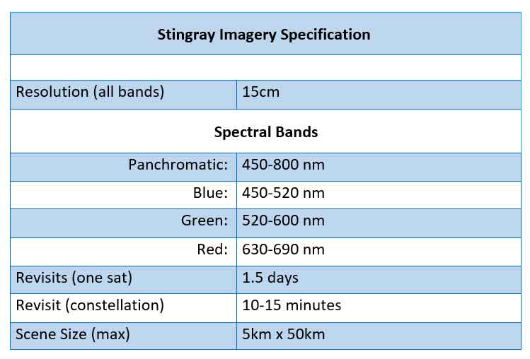
The Stingray Satellite Constellation is a unique system of very low-flying satellites designed to collect ultra-high-resolution Earth imagery from Very Low Earth Orbit (VLEO). These satellites leverage proprietary electric propulsion and onboard computing for advanced Earth observation.
Technical specifications
- Orbit
- Very Low Earth Orbit (VLEO)
- Altitude
- 250 km
- Operational lifetime
- Up to five years
- Propulsion system
- Proprietary electric propulsion system (HET-X)
- Onboard processing
- Yes
- Imagery resolution
- 15 cm
About
The Stingray Satellite Constellation, developed by EOI Space, consists of very low-flying satellites operating in Very Low Earth Orbit (VLEO) to capture ultra-high-resolution imagery of Earth. By operating closer to Earth than other satellites, Stingrays achieve the highest resolution views for real-time intelligence, asset monitoring, and situation awareness. The proprietary technology allows these satellites to fly at a much lower altitude and maintain it for up to five years, which dramatically increases data resolution, reduces satellite production costs, and lowers the risk of space debris impacts. The constellation utilizes a proprietary electric propulsion system called HET-X, which has undergone testing in cooperation with the US Air Force, to maintain a consistent altitude of 250km. Stingray satellites are optimized for the VLEO environment with a low cross-sectional area to minimize atmospheric drag, making them highly maneuverable and capable of collecting imagery at long distances at high, off-nadir angles. Each Stingray is equipped with the latest space-based computing hardware to process imagery onboard, significantly reducing the time to deliver high-priority orders by moving parts of the image processing chain from ground to spacecraft. The constellation offers various imagery services including Priority Imagery for national security, Tasking for leasing capacity to governments, OnDemand Imagery with high capacity and revisits for various industries, and Library Imagery for historical data. These services support applications across numerous industry segments such as renewables, disaster management, infrastructure, defense, taxation, maritime, energy, insurance, economic analysis, transportation, compliance, and environmental monitoring.
Documentation
No public datasheet yet — request the datasheet / ICD from the supplier.