Beijing Series Satellite True 3D Scene Data Products
 21st Century Space
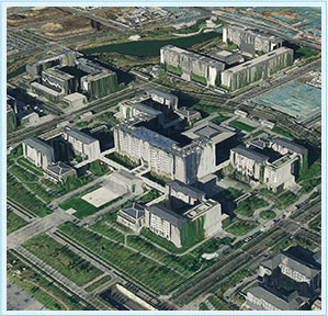
Utilizing Beijing-3 satellite's wide-area stereo imaging and tri-stereo image data, this product automatically generates ultra-high precision DEM/DSM and creates next-generation satellite "true 3D" scene products.
Technical specifications
- Resolution
- 0.8 meter
- Resolution (2)
- 3.2 meter
About
The Beijing-3 satellite’s wide-area stereo imaging and tri-stereo image data can be used to automatically produce ultra-high precision DEM/DSM, creating a new generation of satellite “true 3D” scene products to assist in the construction of digital Earth and real-world China. The 3D scene (3DMesh) product utilizes satellite high-precision stereo imaging technology to generate 3D visualization products that reflect the location, geometric shape, surface texture, and attribute information of geographical elements, including various major geographical information on the Earth. The White Architecture Model (WAM) product is a deeply processed product of the 3D scene product. It is based on satellite orthophotos and digital surface models, using artificial intelligence technology to extract and integrate building boundaries and height information, thereby forming a structured and individualized building product. The Digital Surface Model (DSM) product accurately expresses the undulation information of the Earth’s surface, storing elevation data in triangular mesh or standard grid format.
Documentation
No public datasheet yet — request the datasheet / ICD from the supplier.